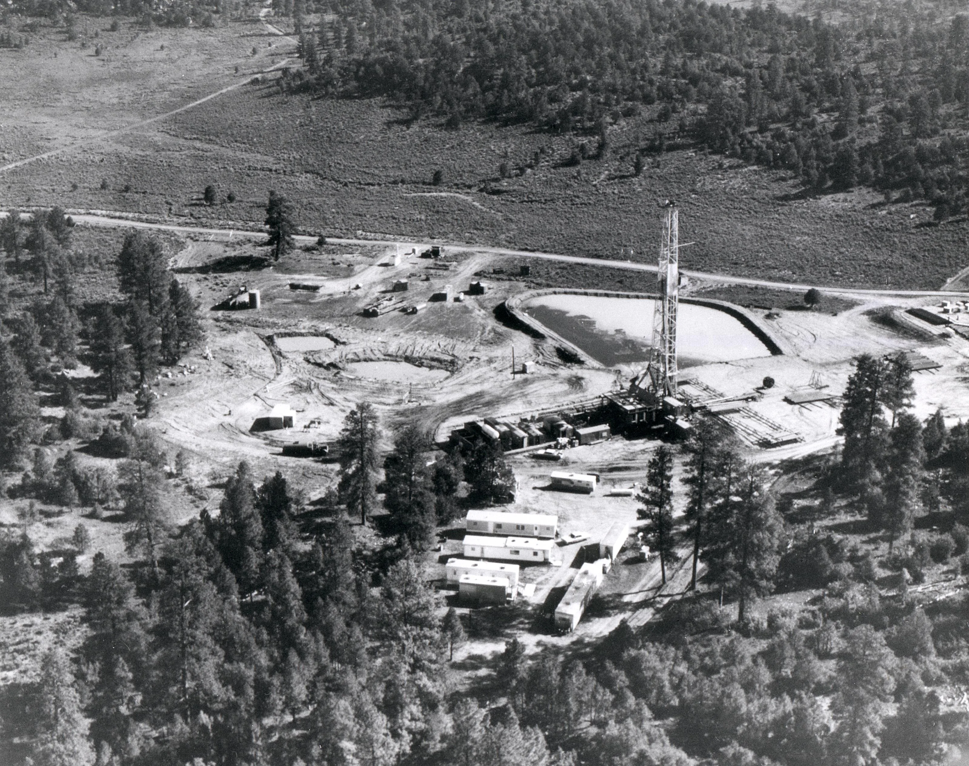
On Sunday, December 10, 1967, at exactly 12:30 p.m. Mountain Standard Time, a crowd stood on a butte in northwestern New Mexico and waited for the ground to move.
There was no mushroom cloud. There wasn't supposed to be. Almost five hundred people from industry, government, the press, and science had come out to watch Project Gasbuggy, the first time the United States tried to loosen a natural-gas field with a nuclear bomb. The device sat 4,227 feet down a well in the Carson National Forest, in Rio Arriba County, about fifty-five miles east of Farmington and roughly twenty miles southwest of Dulce, the small town that is the headquarters of the Jicarilla Apache Nation. When it went off, the surface jumped. Then it was over.[1]
The yield was 29 kilotons - almost twice the yield of the bomb dropped on Hiroshima - and it was buried so deep that the energy was supposed to stay in the rock. Melt a cavity, fracture the tight sandstone around it, let the gas drain into the hole, and sell it.
The well did produce. The gas was too radioactive to put in a pipeline.
A letter from a gas company
The idea was to use a nuclear explosion the way oilfield crews had long used dynamite and nitroglycerin: set it off at the bottom of a well, crack the tight rock, and let trapped natural gas flow into the hole so you could sell it. That thought was already ten years old when they drilled the Gasbuggy well. In June 1957 the Atomic Energy Commission - the civilian federal agency that then ran U.S. nuclear weapons and the "peaceful" nuclear work - started Project Plowshare, named for the line in Isaiah about beating swords into plowshares. The program's job was to find civilian uses for nuclear explosions: harbors, canals, mining, and, later, oil and gas. Most of the twenty-seven Plowshare detonations between 1961 and 1973 happened at the Nevada Test Site. A few went elsewhere on purpose.[2]
That same year, officers at El Paso Natural Gas - the pipeline company that moved San Juan Basin gas west toward California - wrote Livermore and asked whether a nuclear explosive could do what nitroglycerin did at the bottom of a well, only bigger. Oilfield "shooters" had been dropping dynamite and nitro down holes for a century to crack rock. Hydraulic fracturing, the high-pressure fluid method people now call fracking, already existed in commercial form after 1949. El Paso wanted a still larger crack.[1]
Livermore said the technology wasn't ready. Then, in December 1961 - six years to the day before Gasbuggy - Plowshare set off its first shot, Project Gnome, a 3.1-kiloton blast in a salt bed near Carlsbad, New Mexico. Gnome was not a gas well. It was a contained underground experiment to see how a nuclear explosion behaved in salt, and it vented some radioactivity. The Bureau of Mines looked at the data and wrote that the industrial potential "warrants further careful study." Gasbuggy is the study they meant.
The target was the Pictured Cliffs Sandstone, a Late Cretaceous gas sand in the San Juan Basin that held a lot of methane and would not give it up. The rock was so tight that gas barely moved through it. Nearby conventional wells made tens of thousands of cubic feet a day, not enough to get excited about. The plan was to put the device in the Lewis Shale, about forty feet below the base of the Pictured Cliffs, so the fracture would run up into the gas and not vaporize the whole reservoir.
A joint agreement was signed in January 1967. The AEC, the Interior Department, and El Paso would share the work and the bill, later put at about $4.7 million. Field construction started. The site was a 640-acre section of forest that had been open range - grazing and recreation - until a Public Land Order pulled it for the test.
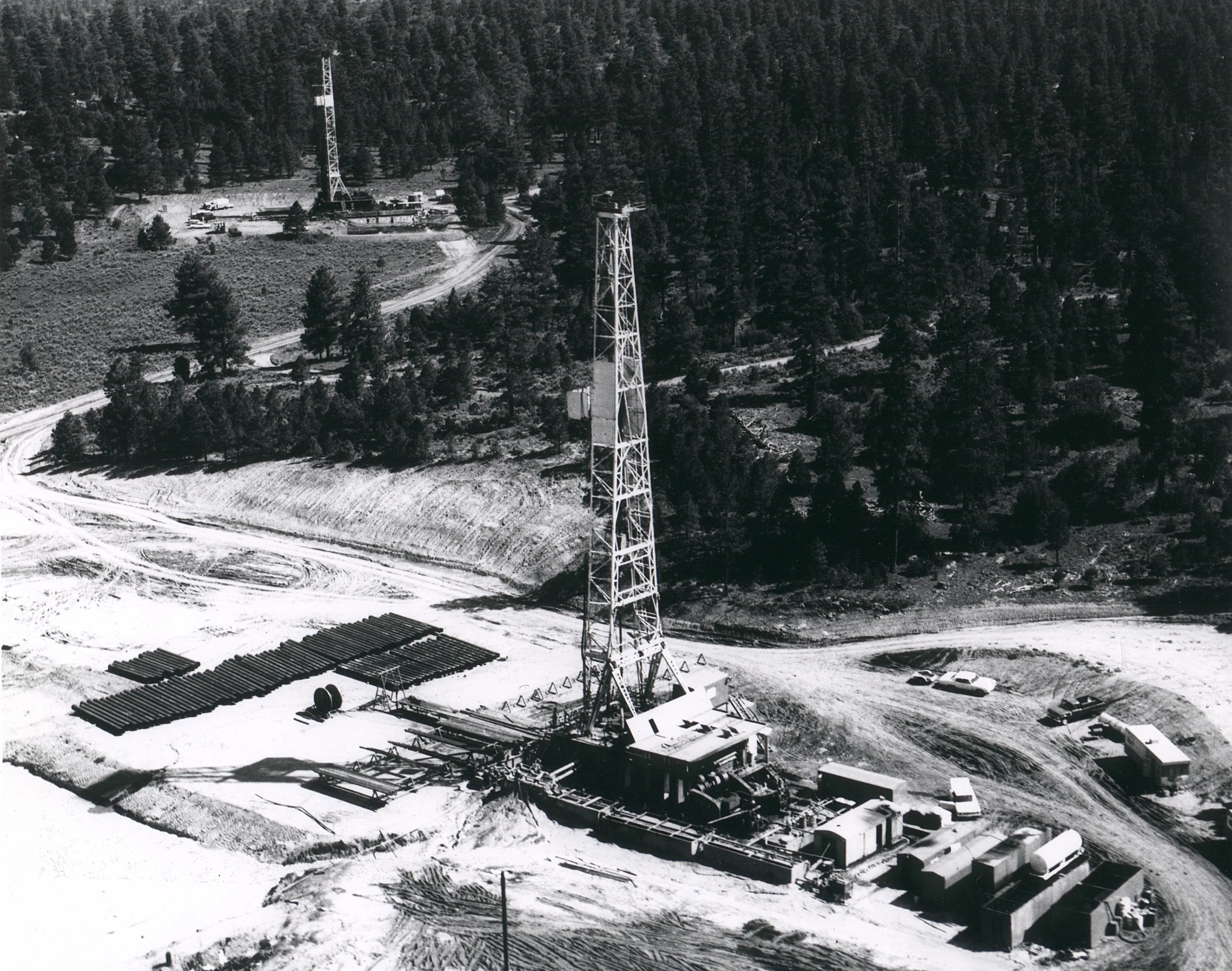
The emplacement well, GB-E, with pipe on the racks. A second derrick stands in the trees behind it. U.S. Department of Energy photograph. Wikimedia Commons, public domain.
They lower the device
James Holcomb, El Paso's site foreman, had shot a lot of wells with nitroglycerin. He watched two white vans roll in with the bomb in pieces. They assembled it in a lead box. "That's not going to do anything," he said later. The canister was about thirteen feet long and eighteen inches across, sized for a 17.5-inch borehole. Design yield was 26 kilotons. After the shot, the official figure was 29.[3]
Two exploratory wells, GB-1 and GB-2, had already been drilled to map the rock and the water. The emplacement hole, GB-E, went to about 4,350 feet. The device was hung at 4,227 feet - some reports say 4,240 - in Section 36, Township 29 North, Range 4 West. Surface ground zero sat at 7,204 feet above sea level. They stemmed the hole with sand and cement the way a nuclear-test crew stems a shaft, so the energy would stay down.
Instruments went in on cables to record shock, cavity collapse, and fracture. Livermore ran the shot. The U.S. Geological Survey put seismometers out at 2,600, 4,200, and 8,400 feet. The Public Health Service watched for radiation. Almost five hundred observers had badges and a place to stand.
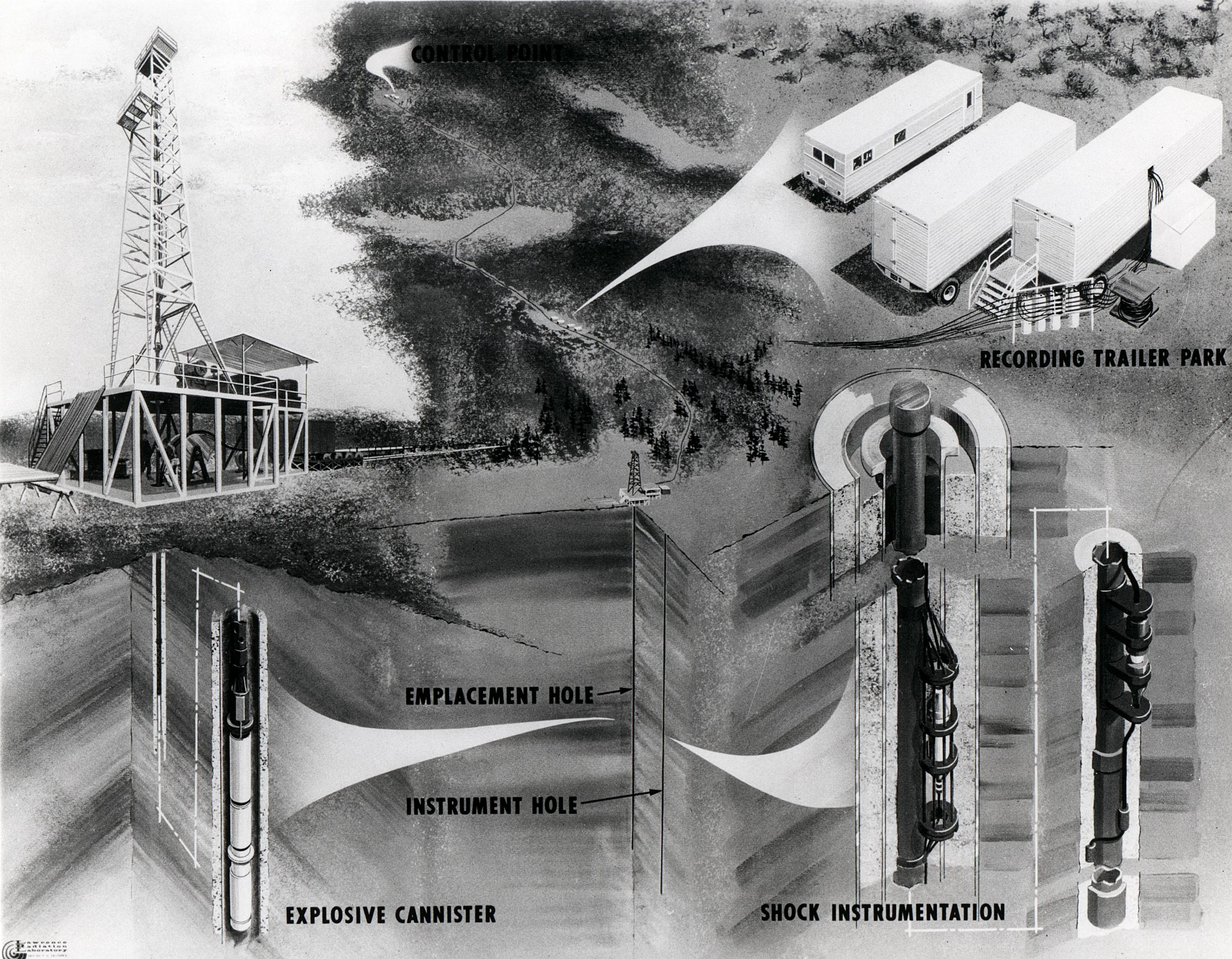
Period illustration of the layout: the derrick over the emplacement hole, the explosive canister, a separate instrument hole, and the recording trailers. U.S. Department of Energy. Wikimedia Commons, public domain.
Sunday at 12:30
There had been delays in the days before. On the morning of the 10th they armed it and ran the countdown. At 12:30:00 MST the device fired. The USGS later wrote that the explosive "performed satisfactorily." Peak particle velocity at surface ground zero was 1.6 meters per second. At 8,400 feet it was 0.4. The closest conventional gas wells, 2,600 feet away, did not break. Navajo Dam and El Vado Dam, roughly forty kilometers out, did not break. A few well sites saw ground cracks and equipment that shifted an inch or three.[4]
Underground, the sequence is the one every contained shot follows. The rock around the device vaporized and melted. A cavity opened, on the order of 160 feet across in later official descriptions. Within about thirty seconds the roof fell in and made a rubble chimney that ran a few hundred feet up, into the Pictured Cliffs. The melt puddled at the bottom and froze into glass, and most of the high-melting-point radionuclides stayed in that glass. There was no surface crater. One hour later, recovery teams found no radioactivity they could measure at the surface. Eight hours later, trace xenon and krypton showed up in the arming cables. The crew cut the cables and let about a curie of activity go.
TIME magazine called it a good start. Holcomb, the El Paso foreman, called it a success once the production numbers came in. The Department of Energy still describes it as the first natural-gas-reservoir stimulation experiment in Plowshare.
Video: the Atomic Energy Commission's own film on Gasbuggy, circulated as The Resourceful Atom. Period footage of the site, the hole, and the pitch for nuclear gas stimulation. [5]
They drill back into the chimney
After the shot, the work that decided the experiment was the re-entry drilling.
A re-entry well, GB-ER, started down toward the chimney. Crews hit weather, stuck pipe, and leftover cement. On January 10, 1968, they found a nine-foot void at 3,907 feet, steel debris, and xenon-133. That was the chimney. A little water came in from the Ojo Alamo Sandstone above, with traces of xenon and tritium - the radioactive form of hydrogen, half-life about 12.3 years, that would decide the whole experiment.
Production testing, in the Department of Energy's official tally, ran from July 1968 through October 1969. Five tests pulled 213 million cubic feet of gas. Flow was several times what the nearby conventional wells made. Livermore later said six to eight times previous rates. Holcomb said the well made more gas in the year after the shot than it had in the seven years before. The gas also came up with carbon dioxide, hydrogen, krypton-85, carbon-14, and tritium. They flared it - burned it at the surface - because nobody was going to put that stream in a kitchen.[6]
Later write-ups give slightly different totals (some say about 295 million cubic feet across a longer test series that ran into 1973). The DOE fact sheet is the number the government still stands on for the five formal tests: 213 million cubic feet, more than the neighbors, and still not a product.
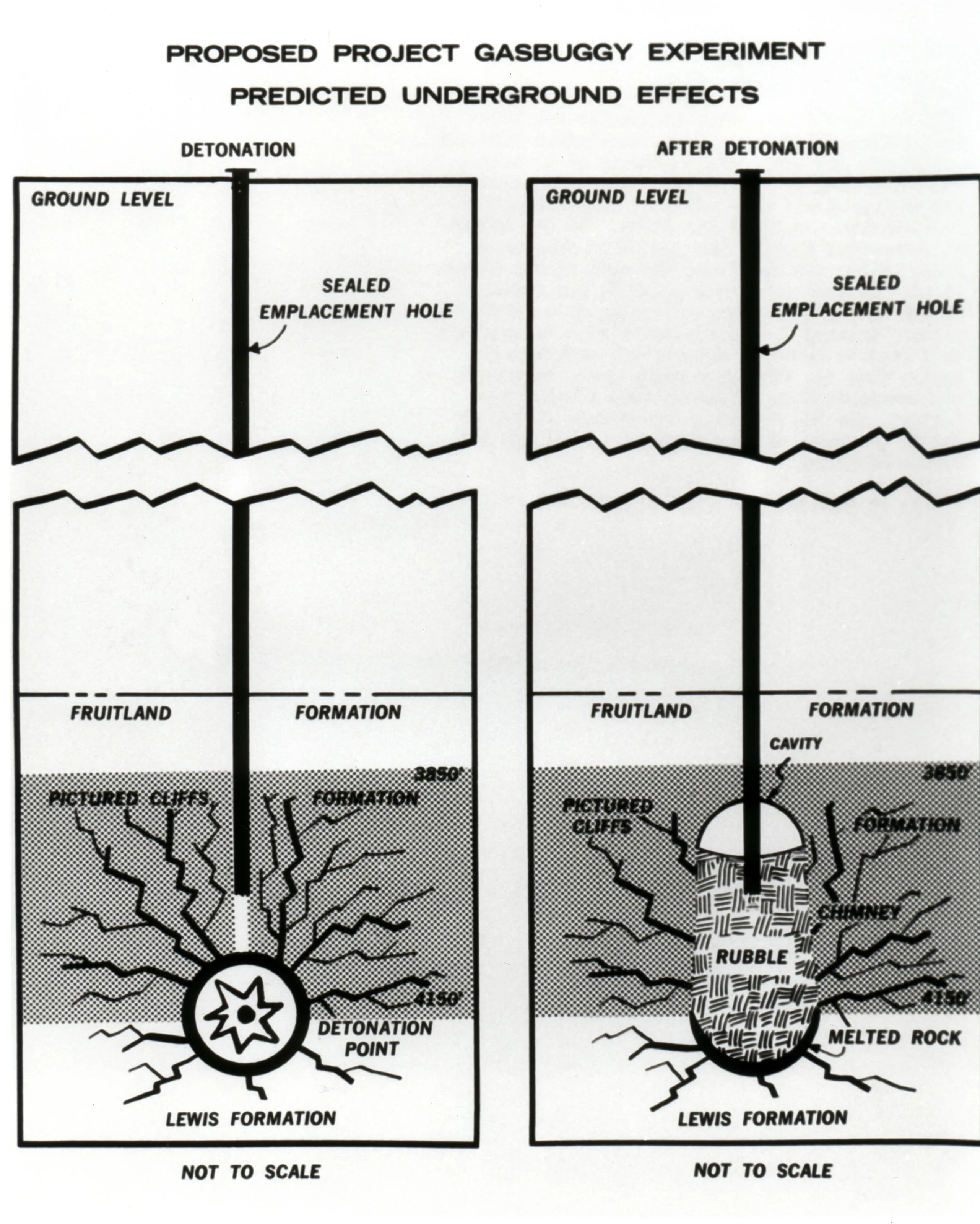
Predicted underground effects: a sealed hole, then a rubble chimney, a cavity, and melted rock in the Lewis Formation under the Pictured Cliffs gas sand. U.S. Department of Energy. Wikimedia Commons, public domain.
The gas is too hot to sell
Tritium is the problem that would not wash out. Neutrons from the explosion make it in the water and the hydrocarbons around the shot. It then trades places with ordinary hydrogen in methane, so it rides out with the gas. You can flare krypton, but you cannot easily strip tritium from a pipeline stream without a plant nobody wanted to build next to a New Mexico well.
Permeability did go up near the chimney. Cores and flow tests said the gain was real within a couple of hundred feet and then faded. The explosion had made a big collection pit. It had not cracked the whole field the way the drawings promised. Evaluators also said the produced gas had a lower heating value than they wanted. In 1976 they decided there would be no more testing. Liquid radioactive waste went back down into the lower chimney. Solid waste went to the Nevada Test Site. The wells were plugged.
In 1978 the Department of Energy poured a concrete monument and bolted on a brass plaque. It says this is the site of the first U.S. underground nuclear experiment for stimulating low-productivity gas reservoirs, 29 kilotons, 4,227 feet, December 10, 1967. It also says you may not excavate or drill within 100 feet of the marker down to 1,500 feet, or within 600 feet of it between 1,500 and 4,500 feet, without federal permission. The Forest Service gave the surface back to grazing and recreation. The bomb, the glass, and the tritium stayed.
Surface cleanup took longer than the plaque. Contaminated soil from the mud pits - 5,562 cubic yards - came out in a final pass finished in September 2004. The Environmental Protection Agency had been sampling springs, ponds, ranch wells, and livestock troughs since 1972, including sites on the Jicarilla Apache Reservation. The DOE says those samples never showed test-related radionuclides. Hydrologic sampling stopped in 2015. In 2009 the department started sampling gas and produced water from nearby commercial wells. As of the current fact sheet, Gasbuggy contaminants have not shown up in those wells either.
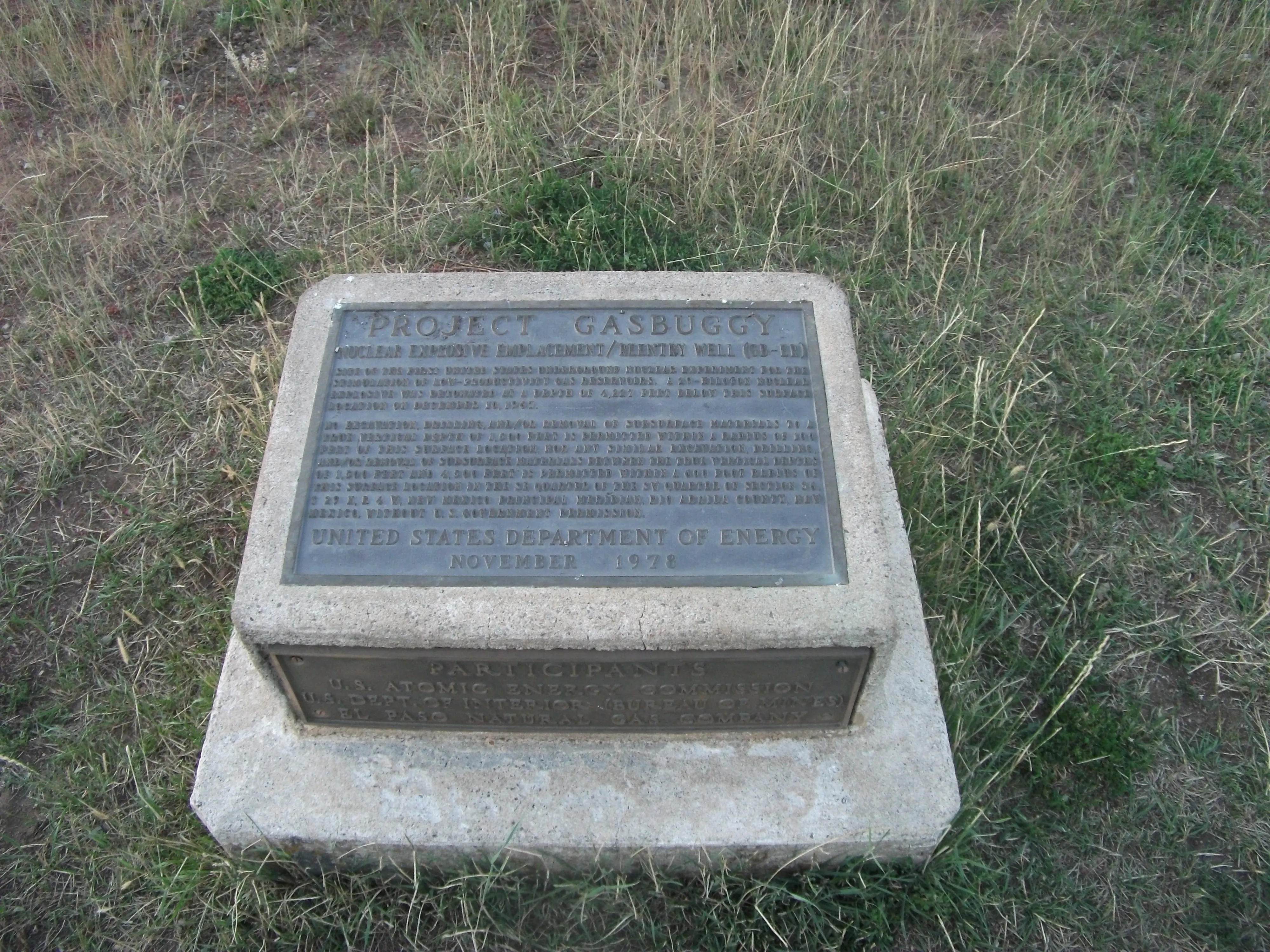
The 1978 monument at surface ground zero. The upper plate names the shot. The lower plate names the Atomic Energy Commission, the Bureau of Mines, and El Paso Natural Gas. Photo by AllenS, 15 Aug. 2011. Wikimedia Commons, CC BY-SA 3.0.
Two more shots in Colorado
Gasbuggy was supposed to be the first of a series. It was. Project Rulison went off on September 10, 1969, near Rifle, Colorado - a 40-kiloton device at 8,426 feet, run this time with Los Alamos, Austral Oil, and CER Geonuclear. The well made gas. The gas had tritium. They flared it. Locals sued. A few protesters walked into the exclusion zone and had to be lifted out by helicopter.
Project Rio Blanco, on May 17, 1973, northwest of Rifle, stacked three roughly 30-kiloton devices in one hole at different depths, hoping a taller chimney would make a cleaner, bigger reservoir. Livermore said the device design was acceptably clean. They got very little usable gas. The geology did not cooperate. Rio Blanco was the last Plowshare field experiment. The program was finished by the mid-1970s; one official cutoff is the end of fiscal 1975, and Livermore dates the formal close to 1977.
The Department of Energy later added up the three gas shots and said about $82 million had gone into nuclear stimulation. Even if you produced every cubic foot they thought was recoverable for twenty-five years, you would get back 15 to 40 percent of the money. By then, hydraulic fracturing - the fluid kind, not the bomb kind - was getting better, and public patience for putting nuclear devices under ranches was gone. The Soviet Union ran a larger "peaceful explosions" program of its own, including gas shots under the name Project NEVA. It reached the same commercial dead end.
Scott Kaufman, the historian who wrote the standard book on the whole effort, Project Plowshare: The Peaceful Use of Nuclear Explosives in Cold War America (Cornell, 2012), treats Gasbuggy as the moment the industrial dream met a pipeline you could not use.
Cattle, Dulce, and Gasbuggy
That would be the end if the hole were only an energy footnote. It isn't, because of where it is.
Dulce is the small town on the Jicarilla Apache Nation about twenty miles from the plaque - the reservation headquarters, a few thousand people, ranching and oil and gas country along the Colorado line. In later UFO writing the name usually means something else: a claimed secret underground facility under Archuleta Mesa, sometimes with aliens, that never turned up as a checkable base. That story is not Gasbuggy. What is local, and on the record, is that in the mid-1970s ranchers around Dulce and the rest of Rio Arriba County started finding cattle dead with soft tissue gone - eyes, tongues, genitals, rectum - and very little blood on the ground.
New Mexico State Police officer Gabe Valdez was stationed in Dulce and took the calls. One of the regular complainants was rancher Manuel Gomez. Valdez logged helicopters, radiation readings on some carcasses, and a suspicion that this was people, not predators and not visitors. He did not think it was aliens. His son Greg, working from those files after Gabe died in 2011, went further. In Dulce Base: The Truth and Evidence from the Case Files of Gabe Valdez (2013), Greg Valdez argues the mutilations were a government sampling program, checking livestock for the aftereffects of radiation from Gasbuggy, "to avoid panicking the public."[7]
That is a claim, not a finding. The FBI's 1970s animal-mutilation file, and later veterinary work, treat most of these carcasses as animals that died and were then worked by blowflies, birds, and coyotes. Decomposition and scavengers can look surgical if you have not stood over a lot of dead cattle. The Gasbuggy-as-sampling story has no declassified order, no lab chain of custody that closes the loop, and a timing problem: the shot is 1967, the Dulce wave that made Valdez famous is 1976, and similar reports were already coming in from Colorado and Kansas. What the story does have is geography. A real nuclear chimney, a real tritium inventory, real EPA sampling on tribal land, and a police officer who was sure the government was on those ranches for a reason.
What is still in the ground
You can drive to the site. There is a small parking area and the 1978 monument. The Forest Service does not restrict the surface. The Department of Energy still owns the deep rights in the southwest quarter of section 36 and still tells drillers to stay out of the chimney. Most of the remaining radioactivity is in the melt glass and the rubble a mile down. Tritium is the mobile piece, and DOE models keep it inside a few hundred feet of the shot point. Nearby producing wells, sampled since 2009, have not shown the test.
Hydraulic fracturing - sand, water, and pressure, not a warhead - is what finally opened tight gas in the San Juan Basin and everywhere else. Gasbuggy proved you can break rock with a bomb. It also proved that the gas you get back remembers the bomb. The plaque in the grass is the honest last line of the experiment. The rest of the story, the part that still gets told in Dulce, is what people built on top of a hole that was never a secret.
Sources
- Lawrence Livermore National Laboratory. "Project Gasbuggy, a plowshare program." Lab history of the 1957 El Paso letter, the January 1967 agreement, the 29-kiloton shot, 500 observers, and the follow-on Rulison and Rio Blanco tests. st.llnl.gov
- Grokipedia. "Project Plowshare." Parent page for the 1957-1970s peaceful-nuclear program, including Gnome, Sedan, Gasbuggy, Rulison, and Rio Blanco. Use this for Plowshare and for Project Gnome, which has no solo Grokipedia page. grokipedia.com/page/Project_Plowshare
- Wells, B. A., and K. L. Wells. "Project Gasbuggy tests Nuclear 'Fracking.'" American Oil & Gas Historical Society. Holcomb and the lead box, the TIME headline, the plaque text, and the $82 million / 15-40 percent DOE arithmetic. aoghs.org
- U.S. Geological Survey. "Surface seismic measurements of the Project GASBUGGY explosion at intermediate distance ranges." Open-file report: Sunday, 10 Dec. 1967, 1230:00 MST, coordinates, 26-kiloton design yield, "performed satisfactorily." usgs.gov
- U.S. Atomic Energy Commission. The Resourceful Atom: Project Gasbuggy. Period film, posted by PeriscopeFilm. youtube.com/watch?v=F3MHOkHApRc
- U.S. Department of Energy, Office of Legacy Management. "Gasbuggy, New Mexico, Site Fact Sheet" (Nov. 2025). Official depth, yield, 213 million cubic feet, chimney, cleanup yardage, plaque, Jicarilla sampling, and the 2009 gas-well program. The primary government page for the site. energy.gov/lm
- "Book claims government behind cattle mutilations." Santa Fe New Mexican, 23 Sept. 2013. Greg Valdez on his father's files and the nuclear-testing / Gasbuggy reading of the Dulce carcasses. santafenewmexican.com
- Grokipedia. "Project Gasbuggy." Encyclopedia overview of the shot, the Pictured Cliffs target, tritium in the produced gas, and long-term monitoring. grokipedia.com/page/Project_Gasbuggy
- Kaufman, Scott. Project Plowshare: The Peaceful Use of Nuclear Explosives in Cold War America. Cornell University Press, 2012. The book to read for the whole program, not just this well. amazon.com
- Valdez, Greg. Dulce Base: The Truth and Evidence from the Case Files of Gabe Valdez. 2013. The Gasbuggy-as-livestock-sampling argument, from Gabe Valdez's case files. amazon.com
- Grokipedia. "Cattle mutilation." Parent article for Gabe Valdez (no solo page) and for the scavenger / FBI reading of the 1970s carcasses. grokipedia.com/page/Cattle_mutilation
- Grokipedia. "Dulce, New Mexico." Town, Jicarilla headquarters, and the later base folklore. grokipedia.com/page/Dulce,_New_Mexico
- Grokipedia. "Project Rulison." The 1969 Colorado follow-on shot. grokipedia.com/page/Project_Rulison
- Federal Bureau of Investigation. The Vault: Animal Mutilation. The 1970s federal file on the Western carcass reports, including New Mexico. vault.fbi.gov
- U.S. Department of Energy, Office of Legacy Management. Gasbuggy, New Mexico, Site - documents and contact page. energy.gov/lm/gasbuggy-new-mexico-site
- Wikipedia. "El Paso Natural Gas." No honest Grokipedia page for the pipeline company; this is the namesake fallback. Notes the 1967 Gasbuggy partnership. en.wikipedia.org
- U.S. Department of Energy. Photograph HD.8A.006 - aerial of the Gasbuggy experiment site. Wikimedia Commons, public domain
- AllenS. Photograph of the Project Gasbuggy monument, 15 Aug. 2011. Wikimedia Commons, CC BY-SA 3.0
- Bishop, Greg. Project Beta: The Story of Paul Bennewitz, National Security, and the Creation of a Modern UFO Myth. 2005. For the Kirtland campaign that later used Dulce. amazon.com
Further reading
← Back to 🗺️ strange_places
Related:
Paul Bennewitz ·
Skinwalker Ranch ·
Project Stargate